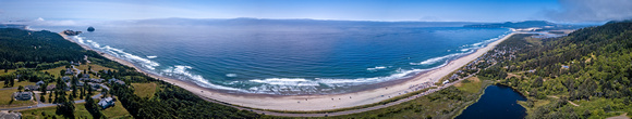
Cape Kiwanda to Cape Lookout
Captured on the Oregon coast, this panorama photo covers about a 180 ° view. Cape Kiwanda can been seen on the left and Cape Lookout on the right of the photo. The beach below and the gathering of homes on towards the left is Tierra Del Mar, Oregon (where we have a beach house).
Photographer’s Notes: Four photos were merged to create the panorama. The photo capture was done with a drone. The drone is programmed to fly no higher than 400 feet (120 m) in altitude – the FAA limit. But, it turns out the limit applies to the elevation from the takeoff point … and that is how the device software is programmed. So, to get this photo, I walked to the highest point having a clear opening (higher points are covered with the canopy of the coastal forest) and launched the drone from there … getting me to about 800 feet (240 m) total elevation above the ocean below.
DJI FC220, f/2.2 @ 4.73 mm, 1/320, ISO 100, No Flash
© Ed Ruttledge